
79 são vicente, cape verde

First island(s) of the Cape Verde archipelago, how exciting!
The island country of Cabo Verde consists of 10 volcanic islands, located 570 km off the coast of Western Africa. They were uninhabited until the 15th century, when the Portuguese discovered the islands. Their name means Green Cape and comes from the name of nearby peninsula, Cap-Vert, on the coast of Senegal.
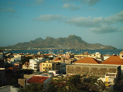
Those cards were sent from the São Vicente island. (You can see some views from there on the photos in the end of this post.) It was discovered on January 22, Saint Vincent's Day, which explains its name. Most of the island's residents (including Lucía who was so kind to send those cards) live in the town called Mindelo. For many years the Porto Grande bay (where the town is located) was the largest harbour in the Atlantic, where you could meet sailors from around the world. Nowadays Mindelo (and the whole island) is still a cultural centre of the Cape Verdean archipelago.

First postcard shows the island called Sal. It is "the sunniest" island of archipelago, with beautiful waters and sandy beaches, and that's why it's the most touristic island of the country. You can also see the traditional Capeverdean colourful rowboats, and as Lucía wrote "it's wonderful to go to the beach and see fishermen coming back and sometimes even selling fish to whoever passes by!"
The second card shows Maio, "the secluded island", which is small and not that touristic (and because of that it's also difficult to find cards from there - thank you for the effort Lucía!). As you can see it has this interesting 'lunar' landscape, completely not fitting to the country's name, but it is really fascinating to see how the landscape varies on the islands, there are sandy beaches, dry mountainous regions or green hills (just look at Santo Antão). And of course don't forget the volcanic nature of the archipelago, if you visit the island's FB page, you can see photos showing damages after the eruption on Fogo island last november.


São Vicente
- country
- Republic of Cabo Verde
- location
- 570 km off the coast of Western Africa
- inhabitants
- 79,374
- largest town
- Mindelo
- postcard sent
- postcard received
- distance travelled
- ~5256km
- sent from
- Mindelo

3 comments
Kartka z łodziami jest super.
ReplyDeletezgadzam się :)
Deletechociaż drugą też lubię,
za to jaki kontrast pokazuje!
Piękna ta pocztówka z osiołkiem, gratuluję :)
ReplyDelete